NASA Captures Stunning Morning Fog in Australian Alps
NASA's Terra satellite documented dense morning fog blanketing valleys in Australia's Victorian Alps during autumn. The phenomenon occurs as cool air sinks, trapping moisture in shaded mountain basins.
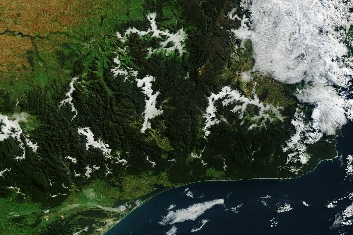
Morning fog blanketed the valleys of Australia's Victorian Alps in May, creating a striking scene captured by NASA's Terra satellite. This natural display occurred during the autumn season in the Southern Hemisphere, when longer nights allow the atmosphere more time to cool, leading to the condensation of water vapor into radiation fog.
Radiation fog typically forms on clear, calm nights when the ground loses heat to space. As this occurs, the air layer directly above the ground cools. When this air cools to its dew point, the air becomes saturated, and water vapor condenses into fog droplets. Cold air, being denser than warm air, sinks and collects in low-lying areas, such as valleys. While this fog often dissipates as the sun warms the ground, it can persist in mountain valleys that remain in shade for extended periods. Geostationary satellite imagery from that day indicated the fog remained for approximately two hours.
Valley Fog and Arching Clouds
The persistent fog in the Victorian Alps was facilitated by recent weather patterns. A period of cold, moist weather preceding the satellite's observation had saturated the land surfaces. This was followed by a slow-moving high-pressure system that brought calmer, warmer conditions ideal for fog formation. Many of the valleys in this mountainous region are also home to rivers, streams, and lakes, such as the Mitta Mitta River, Buffalo River, Livingston Creek, Lake Dartmouth, and Snowy River. These water bodies provided an abundant source of water vapor, amplifying the fog-forming process. In the captured image, distinct zones of fog are visible along these waterways.
The same atmospheric conditions also contributed to another notable cloud formation hundreds of kilometers to the southwest. Around 8:19 a.m. local time, the Terra satellite documented an arch-shaped cloud forming over Port Phillip Bay. This cloud stretched from St. Leonards on the bay's western shore to Mount Eliza on the eastern side. Researchers suggest this unique formation may have resulted from the interaction of converging land and sea breezes with the distinctive, horseshoe-shaped terrain surrounding the bay.
This phenomenon highlights the complex interplay of weather, geography, and season. As the valley fog in the northeast began to fade, the arch-shaped cloud over Port Phillip Bay was observed moving southward across the water. The detailed imagery from NASA provides a valuable glimpse into atmospheric processes and their visual manifestation on Earth's surface, particularly in remote and mountainous regions like the Victorian Alps.