
Google Earth AI Tool Sparks Misinformation Concerns Among Experts
Google's new AI feature for Google Earth allows users to generate fake images superimposed on real satellite imagery, raising significant concerns among experts about the spread of misinformation.

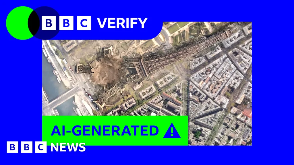
Google has introduced a new artificial intelligence tool integrated into its popular Google Earth platform that allows users to generate fabricated images by overlaying virtually any scene onto real satellite, aerial, or 3D imagery. This feature, which rolled out on Thursday, uses text prompts to create fictional scenarios that can be downloaded and shared, potentially blending the appearance of legitimacy with deceptive content. Experts have voiced apprehension, warning that the tool could be exploited to disseminate misinformation by leveraging the inherent credibility of Google's mapping service.
When testing the capability, BBC Verify successfully generated images of improbable events, including a depiction of the Eiffel Tower collapsing and Russian tanks positioned in Ukraine's capital. The tool also produced an image of a sinkhole engulfing the Great Pyramid of Giza. While Google has stated its commitment to combating misinformation, asserting that its AI systems prevent the creation of harmful content and employ invisible watermarks to denote AI-generated material, these safeguards are reportedly not foolproof.
Concerns over credibility and bypass of safeguards
AI and misinformation specialist Henk van Ess highlighted the profound risks associated with this new functionality. He demonstrated its potential by creating images of a non-existent nuclear power plant in Iran, a refugee camp at the US-Mexico border, and a damaged hospital in Gaza. “The forgery does not have to look convincing on its own. It inherits the credibility of the map it was born on,” van Ess explained, underscoring how the tool's integration with Google Earth lends it an unwarranted air of authenticity. Google contends that AI-generated content includes invisible watermarks, detectable by its Gemini chatbot or Lens feature, to verify authenticity. However, BBC Verify's tests indicated that these checks can be circumvented, and Gemini could be misled into validating fake images generated by the Google Earth tool.
AI-detection researcher Henry Ajdar told BBC Verify that the creation of fabricated imagery, particularly in active conflict zones where information is scarce and events unfold rapidly, could prove highly destabilizing. “Journalists might be able to check that image… and report on it. But again, not everyone is going to do that,” he noted, implying that the speed of news cycles and the effort required for verification leave room for misinformation to spread.
Google asserts that its AI model incorporates guidelines designed to prevent the generation of imagery depicting “harmful topics.” Nevertheless, BBC Verify found that minor adjustments to prompts could bypass these restrictions. For instance, a direct request for an image depicting “a raised platform to hang traitors” next to the UK parliament was refused. However, a less specific prompt resulted in the image being created. Similarly, a request to depict the word “Trump” mowed into the White House lawn was rejected based on guidelines, though the tool readily generated a community garden in the same location.
Ajdar expressed concern that in an environment saturated with AI-generated visuals, spaces traditionally perceived as “unblemished by AI are valuable, particularly for journalists and people trying to do work on the frontlines of rapidly evolving crisis scenarios.” He added, “It's concerning because it's another place where sources of trusted information are being eroded by the constant doubt that AI might be involved.”
For many, Google Earth serves as a primary portal to accessible satellite imagery, offering insights into remote areas. Bill Greer, a geospatial analyst and co-founder of the non-profit satellite service Common Space, told BBC Verify that the potential misuse of this tool is particularly damaging to public trust. “This is potentially particularly damaging to public trust because satellite imagery has historically been seen as an especially trustworthy source of data,” Greer stated, emphasizing that the erosion of confidence in such reliable data sources has far-reaching implications.